UK Map App
Since Ordnance Survey doesn't include any free footpath data in its OpenData offering, UK Map's free maps superimpose paths using data from OpenStreetMap. Although this works well it's not perfect; there are still gaps where the OpenStreetMap surveyors have yet to go.
An alternative source of free footpath data is the local highway authorities, who are responsible for the legal record public rights of way. Much of this data has been collected at the rowmaps website.
This page reviews the pros and cons of each data source. My conclusion is that for the time being it is best to stick with the OpenStreetMap paths - but I would value comments from users about what you would prefer. I look forward to your feedback.
OpenStreetMap is a volunteer project to build a free map of the world, using on-the-ground surveys, tracing from aerial imagery, and sometimes imports from suitably-licensed free data.
Currently, I read data from the OpenStreetMap database and use the tags that the OpenStreetMap contributors have added to filter out what seem to be footpaths, bridleways etc. I then superimpose these paths onto the Ordnance Survey base maps.
Although this generally works well, there are a few problems:
Highways Authorities, which are generally councils, keep the legal records of rights of way in their areas. In many cases they have made digital versions of this data available with terms of use that would allow it to be used on UK Map's free maps.
Barry Cornelius has gathered together much of this data at his website, rowmaps.com. He has made available the original data from the councils, and has also converted it to other formats.
At first glance this data might seem to fix some of the problems with the OpenStreetMap data, but there are a number of potential problems:
If you would like to see the rowmaps data yourself you have a couple of options. The rowmaps website has a map (which works only in Firefox or Chrome, so not on an iPhone or iPad) where you can view their paths superimposed on an Ordnance Survey map (via Bing) or on an OpenStreetMap map.
Alternatively, you can try to view the paths in UK Map using GPX files. There are per-council GPX downloads on the rowmaps website but their appearance in UK Map is not ideal. I've prepared slightly modified versions which work in UK Map, at least on reasonably new devices; they may be too large for devices more than perhaps 3 or 4 years old. Download this 63 MB ZIP file. It contains five GPX files, each for a "slice" of the country from South to North.
Note: these examples show the June 2021 versions of the free maps which include OpenStreetMap paths from around that date; it's possible that the paths have improved since then.
In each case the maps are:
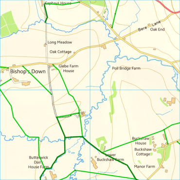
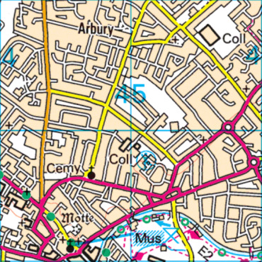
On the rowmaps maps, footpaths are bright green solid lines, bridleways are slightly thicker and darker green solid lines, and other byways are even darker and thicker. The dotted or dashed lines are the OpenStreetMap paths.
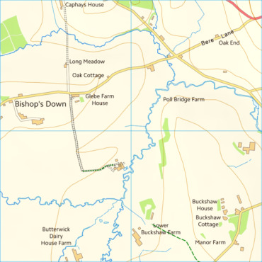
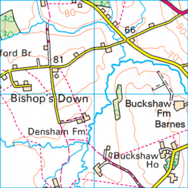
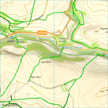
This example, from Dorset, shows an area where the OpenStreetMap data is lacking; it has almost none of the area's footpaths. These are included in the rowmaps data, which agrees with the paid OS map. Note the short section of track North of Long Meadow, which OpenStreetMap records as a track and Ordnance Survey records as an "Other route with public access", but which is missing from rowmaps.
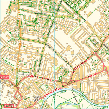
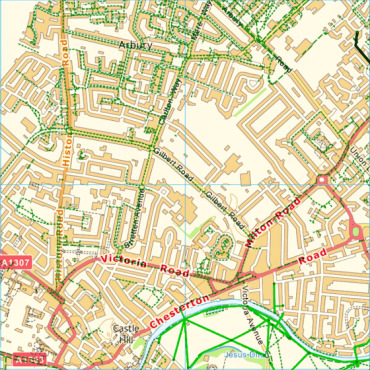
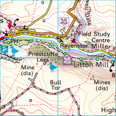
Here's an urban area - Cambridge - where most of the OpenStreetMap paths that I am showing are actually roadside cycle paths (it's difficult for me to separate these from non-roadside cycle paths, which do need to be included). Some of the OpenStreetMap paths are short passages between streets which would be useful to include, except that in some cases the base map doesn't have enough detail for them to be understood. The only actual footpaths are in the riverside park at the bottom of the map, where the rowmaps paths correspond with what Ordnance Survey shows.
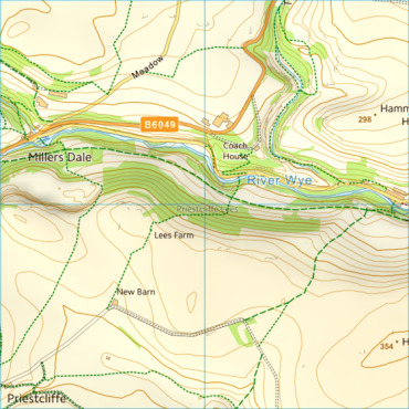
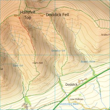
This example, from the Peak District, shows an important path that is not a legal right of way - it's a disused railway. The OpenStreetMap data seems to have all of the footpaths and also shows the railway path; the rowmaps data doesn't have it.
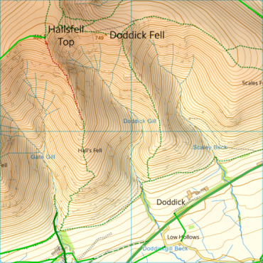
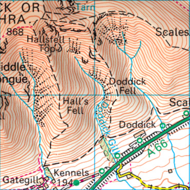
This example shows mountain paths, many of which are not rights of way, but because this is Access Land public access is allowed on all of these paths, rights of way or not. The Ordnance Survey map shows all of the paths and distinguishes between the footpaths and the other paths. OpenStreetMap also shows all of the paths, but as the rowmaps data only includes the actual rights of way, it is missing many important paths.
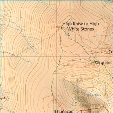
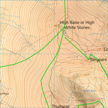
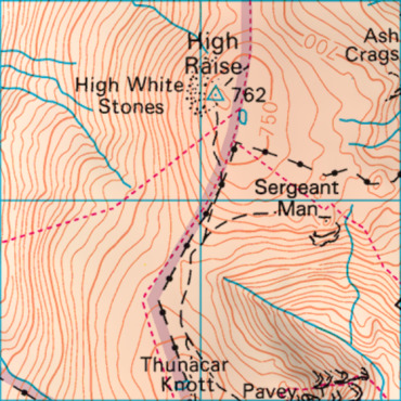
This example shows a mountain path where OpenStreetMap accurately shows the position of the path on the ground, while the rowmaps path is just an approximation. Ordnance Survey seem to show both the right of way and the physical paths - and also add a boundary line for extra confusion.
My conclusion is that the greatest benefit of using the rowmaps data would be in examples like the first, where paths are missing from OpenStreetMap. But that's a problem that will eventually be resolved as OpenStreetMap's volunteers survey these gaps. On the other hand, the loss of non-right-of-way paths in other places, particularly as shown in the third and fourth examples, would be a serious loss to the map. So I intend to keep the current OpenStreetMap paths for the time being.
Your comments about this would be much appreciated.